Location, location, location!
When it comes to building contextually relevant applications, it’s all about location. By enabling functionality tied to location, an application can move from being just a convenience to a necessity! Your app can move to the “must have” category by helping with real world tasks, answering questions like “Where should I buy a house?”, “Is this a good area for our new store location?” and more.
The Bing Maps team has been hard at work releasing three new REST APIs that bring the power of location-based search to maps scenarios – Bing Maps Location Recognition, Bing Maps Local Search API and Bing Maps Local Insights API. Let’s go into detail about each of these APIs and see examples of how they can be used to light up new, location-related possibilities.
Location Recognition API
Get details about points of interest at a specific location with Bing Maps Location Recognition API.
Much like an in-car mapping solution, when given location coordinates (latitude/longitude), the Location Recognition API returns a comprehensive description of the location along with points of interest. Your application can easily receive the data in the form of a JSON or XML response. The response includes:
- Business entities at the location with a wide range of types supported (e.g. restaurants, hotels, parks, gym, shopping malls and more)
- Natural entities at the location (e.g., beaches, island lakes, and 9 more)
- Reverse geocoded address of location
- Type of property at the location (e.g., residential, commercial, etc).
The Bing Maps Location Recognition API helps answer questions like, "What are the businesses and points of interest near a real estate property that I am interested in buying?" or "What is the address associated with a given latitude/longitude? Is it a private residence? What neighborhood am I in?"
For more details about the API parameters, entity types and examples, check out the documentation.
Local Search API
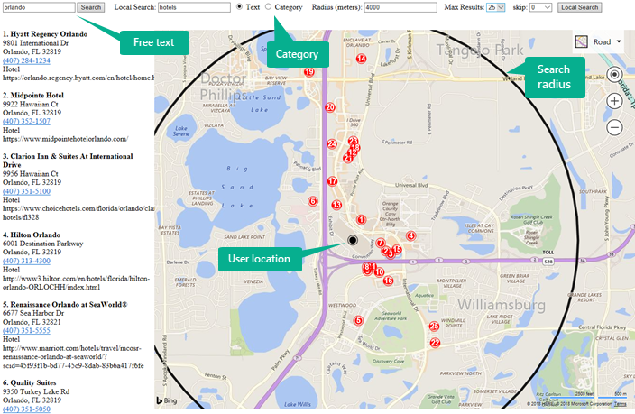
Need to know what businesses are nearby? As an area-based search by business name, category or free text, Local Search API could be the answer.
Bing is well known for our vast local business data aggregated from providers around the world and Bing Maps is now exposing that rich location based data through this API. You can leverage the breadth of the same dataset powering local search on bing.com within your applications and services with Bing Maps Local Search API.

With responses supported in JSON and XML, the output can be used for retail planning and site selection, but more commonly for finding a business that offers a specific service. For example, “Where is the closest vegan restaurant?”
For more details about the API parameters and examples, check out the documentation.
Local Insights API
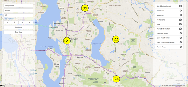
Bing Maps Local Insights API can help get insights into businesses and entities within a given area reached by driving, walking or public transit within a given time or distance.
Local Insights can help score the attractiveness of a location based on the proximity to points of interest, making it easy for you to determine how close you are to things that are important to you. Find out how many restaurants, bars, movie theaters, parks or other kinds of places are nearby and also take into consideration the predicted traffic at a specific time of day. For example, “How many schools are within walking distance from this location?” or “How many restaurants are within a 10 minute drive at 5pm?”

For more details about the API parameters and examples, check out the documentation.
Note: Both Local Search API and Local Insights API are available in the United States with plans to make them more broadly available in the near future.
We are excited to see what you build with these new APIs. To learn more about the full suite of Microsoft Mapping options, Bing Maps APIs and how to get licensed, go to https://www.microsoft.com/maps.
– Bing Maps Team
Source: Bing Blog Feed